Sorry for my long silence because of many troubles with the UAV flight
observation. Please refer to reports from Hattori-san about the troubles.
I would like to introduce of a case of coastal heavy rainband (CHeR)
observed in the early morning on December 12. If you have a broad band
network, please check out the following animation image:
http://turbulence.ddo.jp/morishu/harimau2011/mia_xdr_cappi2kmz111212.gif
Weak echoes were started to be observed after 0600LT, and then they were
integrated as a CHeR line inwith parallel to the coastline by 0800LT.
The CHeR was generated and maintained along a weak convergence zone
between southerly and southeasterly winds blown from Mentawai and
Sumatera Islands, respectively.
The CHeR has been weaken and spread after 0930LT when wind from Sumatera
Island changed its direction from southeasterly (land breeze like
direction?) into southerly (see breeze like direction?).
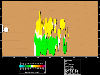
A vertical cross section view of CHeR (RHI for 225deg) shows inbound
flow (southwesterly component) below 4-5 km with very small convergence
in its northeastern side, and out flow (northeasterly component) above
it. This strong vertical wind sear may have an important role to
generate and maintain the CHeR, too.
I welcome your comments and further discussion.
Originally, we would have planned to make a UAV flight observation which
penetrates the CHeR from Tabing to Sipora by different altitude to
examine environmental condition in and out of the CHeR! Huuuum.
~morishu


No comments:
Post a Comment